Storms possible Thursday night
Published 11:30 am Thursday, October 31, 2013
Isolated severe storms will be possible Thursday night ahead of an approaching cold front.
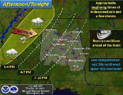
The main threat will be damaging straight-line winds and should be contained to areas west of Interstate 65 and north of Interstate 20 between 6 p.m. and midnight, according to the National Weather Service in Birmingham.
Breezy conditions are expected Thursday ahead of the cold front. Winds from the south of 15 to 25 miles per hour are in the forecast with higher gusts expected, especially at higher elevations.
The weather turns cooler this weekend, with lows down in the 40s and highs in the mid- to upper-60s.